Apple River above Park In Somerset, WI: water level and flow
USGS gauge 05341498 · observed Nov 19, 8:00 PM CST · 53 min old ·
The river here is below normal for Nov 19 and steady.
216 cfsBelow normal for Nov 19+1.9% flow in 6 hNo active NWS alerts
Flow and gage height at the top updated Nov 19, 8:00 PM CST. Charts, tables and comparisons below are as of the page build, Nov 19, 7:00 PM CST.
cfs = cubic feet of water passing the gauge each second. Gage height is the gauge’s own scale, not water depth. Glossary
More
Flow 24 h earlier: 251 cfs.Not available for this gauge: live water temperature (no USGS temperature sensor at this gauge or within 40 mi on this river); clarity (no USGS turbidity or water-quality sensor at this gauge).
Government data, shown with the time it was observed or issued. It is not a flood warning, and it does not decide for you: no alert does not mean conditions are safe. Disclaimer
What the water is like now
How deep and wide the river is here Historical record#
Source
Source: USGS Water Data API channel measurements (hydrographer site visits within a mile of the gauge; the main channel of each visit), fetched Nov 18, 6:05 PM CST. Average depth = area ÷ width, our math. Credit: Data: U.S. Geological Survey.
About 1 ft deep on average at a flow like today's (216 cfs): on Dec 19, 2023, at 221 cfs, USGS measured the river 144 ft wide with an average depth of 1.0 ft (at the gauge). An average across the whole channel (area divided by width): pools and the main channel are deeper, edges shallower, and depth changes with the flow.
Latest measurement: on Oct 22, 2026, at 257 cfs, USGS measured the river 96 ft wide with an average depth of 1.4 ft (600 ft upstream).
All 10 recent measurements
| Date | Flow | Average depth | Width |
|---|---|---|---|
| Oct 22, 2026 | 257 cfs | 1.4 ft | 96 ft |
| Sep 9, 2026 | 300 cfs | 1.2 ft | 120 ft |
| Aug 7, 2026 | 211 cfs | 1.3 ft | 90 ft |
| Jul 9, 2026 | 370 cfs | 1.3 ft | 110 ft |
| Jun 8, 2026 | 263 cfs | 1.1 ft | 111 ft |
| Apr 7, 2026 | 685 cfs | 1.7 ft | 109 ft |
| Mar 25, 2026 | 526 cfs | 1.4 ft | 104 ft |
| Feb 27, 2026 | 426 cfs | 1.4 ft | 102 ft |
| Nov 20, 2025 | 278 cfs | 1.5 ft | 95 ft |
| Sep 11, 2025 | 405 cfs | 1.6 ft | 94 ft |
How fast the water moves here Historical record#
Source
Source: USGS Water Data API channel measurements (hydrographer site visits within a mile of the gauge, main channel, last 20 years) at flows within 25% of the latest reading, 216 cfs. Mean velocity is the flow divided by the channel's cross-section area at one spot on one day; the times are our arithmetic (distance divided by that speed), not a trip time for any stretch.
At flows like today's, the water here has moved about 1.1 to 1.4 mph (1.6 to 2.1 ft/s, average across the channel, measured by USGS on 4 visits at 211 to 263 cfs). The main current and the surface run faster than the average; pools, eddies and the edges run slower, and wind and stops add time.
| Distance | Time drifting at that speed |
|---|---|
| 1 mile | 42 min to 56 min |
| 3 miles | 2 h 06 min to 2 h 49 min |
| 5 miles | 3 h 31 min to 4 h 42 min |
| 10 miles | 7 h 01 min to 9 h 24 min |
Weather at the river
Hourly weather above Park In Somerset, next 24 hours Official NWS#
Source
Source: National Weather Service gridpoint forecast, updated Nov 19, 4:21 PM CST; chance of rain or snow from the NWS hourly point forecast. Hours are gauge-local; each row covers 3 hours and every hour is one tap below. How this table is built. Credit: Forecasts, alerts and observations: National Weather Service. NWS material is not subject to copyright.
Thunderstorms: none in the National Weather Service forecast for the next 24 hours.
Next 24 h: 36 to 65°F · gusts to 35 mph (2 PM) · rain or snow chance up to 8%.
| Time | Temp | Rain % | Wind mph | Sky |
|---|---|---|---|---|
| Thu 7 PM | 44°F | 0 | ↑ 5–7 | Mostly Clear |
| 10 PM | 38°F | 0 | ↑ 2–6 | Mostly Cloudy |
| Fri 1 AM | 36°F | 0 | ↑ 3–7 | Mostly Cloudy |
| 4 AM | 37°F | 6 | ↑ 8–13 | Mostly Cloudy |
| 7 AM | 43°F | 8 | ↑ 13–23 | Cloudy |
| 10 AM | 53°F | 5 | ↑ 18–32 | Mostly Cloudy |
| 1 PM | 64°F | 6 | ↑ 21–35 | Mostly Cloudy |
| 4 PM | 65°F | 8 | ↑ 18–33 | Mostly Cloudy |
Every hour
| Time | Temp | Rain % | Wind mph | Sky |
|---|---|---|---|---|
| Thu 7 PM | 44°F | 0 | ↑ 5–7 | Mostly Clear |
| 8 PM | 42°F | 0 | ↑ 3–5 | Partly Cloudy |
| 9 PM | 40°F | 0 | ↑ 1–3 | Mostly Cloudy |
| 10 PM | 38°F | 0 | ↑ 0–2 | Mostly Cloudy |
| 11 PM | 37°F | 0 | ↑ 1–3 | Mostly Cloudy |
| Fri 12 AM | 36°F | 0 | ↑ 2–6 | Mostly Cloudy |
| Fri 1 AM | 36°F | 0 | ↑ 2–6 | Mostly Cloudy |
| Fri 2 AM | 36°F | 0 | ↑ 2–6 | Mostly Cloudy |
| 3 AM | 36°F | 0 | ↑ 3–7 | Patchy Fog |
| 4 AM | 37°F | 2 | ↑ 5–7 | Mostly Cloudy |
| 5 AM | 38°F | 4 | ↑ 6–9 | Mostly Cloudy |
| 6 AM | 41°F | 6 | ↑ 8–13 | Mostly Cloudy |
| 7 AM | 43°F | 8 | ↑ 9–17 | Cloudy |
| 8 AM | 45°F | 6 | ↑ 12–21 | Cloudy |
| 9 AM | 49°F | 5 | ↑ 13–23 | Cloudy |
| 10 AM | 53°F | 5 | ↑ 15–28 | Mostly Cloudy |
| 11 AM | 57°F | 5 | ↑ 16–28 | Cloudy |
| 12 PM | 61°F | 5 | ↑ 18–32 | Mostly Cloudy |
| 1 PM | 64°F | 6 | ↑ 20–33 | Mostly Cloudy |
| 2 PM | 65°F | 5 | ↑ 21–35 | Mostly Cloudy |
| 3 PM | 65°F | 5 | ↑ 20–33 | Mostly Cloudy |
| 4 PM | 65°F | 6 | ↑ 18–33 | Mostly Cloudy |
| 5 PM | 64°F | 7 | ↑ 17–31 | Mostly Cloudy |
| 6 PM | 61°F | 8 | ↑ 18–29 | Cloudy |
7-day weather above Park In Somerset Official NWS#
Source
Source: National Weather Service point forecast, updated Nov 19, 4:21 PM CST. Each card is one day: the daytime period and the night after it (high / low, and the chance of rain or snow for each).
Every NWS forecast period, in full
| Period | Temp | Wind | Rain or snow | Forecast |
|---|---|---|---|---|
| Tonight | 36°F | Calm | 4% | Patchy fog between 3am and 4am. Mostly cloudy, with a low around 36. South southeast wind 0 to 5 mph. |
| Friday | 65°F | SSE 10 to 20 mph | 8% | Mostly cloudy, with a high near 65. South southeast wind 10 to 20 mph, with gusts as high as 35 mph. |
| Friday Night | 55°F | S 15 to 20 mph | 30% | A chance of rain showers after 3am. Cloudy, with a low around 55. South wind 15 to 20 mph, with gusts as high as 35 mph. Chance of precipitation is 30%. |
| Saturday | 58°F | W 5 to 15 mph | 54% | A chance of rain showers. Cloudy. High near 58, with temperatures falling to around 48 in the afternoon. West wind 5 to 15 mph, with gusts as high as 30 mph. Chance of precipitation is 50%. |
| Saturday Night | 34°F | NW 5 to 10 mph | 43% | A chance of rain showers. Cloudy, with a low around 34. Northwest wind 5 to 10 mph. Chance of precipitation is 40%. New rainfall amounts less than a tenth of an inch possible. |
| Sunday | 39°F | NW 10 to 15 mph | 9% | Partly sunny. High near 39, with temperatures falling to around 35 in the afternoon. Northwest wind 10 to 15 mph. |
| Sunday Night | 22°F | Calm | 1% | Partly cloudy, with a low around 22. Northwest wind 0 to 10 mph. |
| Monday | 35°F | Calm | 0% | Mostly sunny. High near 35, with temperatures falling to around 30 in the afternoon. North northwest wind 0 to 5 mph. |
| Monday Night | 17°F | Calm | 0% | Mostly clear, with a low around 17. North wind around 0 mph. |
| Tuesday | 35°F | Calm | 1% | Mostly sunny, with a high near 35. Southeast wind 0 to 5 mph. |
| Tuesday Night | 19°F | Calm | 6% | Mostly cloudy, with a low around 19. East northeast wind around 0 mph. |
| Wednesday | 36°F | Calm | 3% | Partly sunny, with a high near 36. South southeast wind 0 to 5 mph. |
| Wednesday Night | 18°F | Calm | 2% | Partly cloudy, with a low around 18. Southeast wind around 0 mph. |
Air conditions at weather station KRNH Weather station#
Source
Source: National Weather Service station KRNH, observed Nov 19, 6:30 PM CST.
NWS station KRNH (New Richmond Municipal Airport), 7 mi from the gauge, observed Nov 19, 6:30 PM CST.
| Measure | Value |
|---|---|
| Air temperature | 42 °F |
| Wind | SW 3 mph |
| Pressure | 30.20 inHg, rising |
| Visibility | 10 mi |
Air quality now EPA monitor#
Source
Source: EPA AirNow NowCast AQI, reporting agency Wisconsin Dept. of Natural Resources, nearest monitor to the gauge; preliminary data, subject to change. Fetched Nov 19, 7:03 PM CST. Credit: Air quality: EPA AirNow and the reporting agency named on the row (preliminary data).
Good: AQI 14 of 500 (PM2.5, EPA)
Monitor: Chippewa Valley and Eastern Twin Cities (AirNow reporting area; no single monitor named) · observed Nov 19, 6:00 PM CST
| Pollutant | AQI (of 500) | EPA category |
|---|---|---|
| PM2.5 | 14 | Good |
| PM10 | 11 | Good |
Recent rain at the gauge location Official NWS#
Source
Source: NWS River Forecast Center multisensor precipitation estimate, about 2.5-mile grid at the gauge location, fetched Nov 19, 7:03 PM CST. Estimate, not a gauge at the stream. Each window is a separate NWS product with its own end time (hourly and daily products), so a longer window can end earlier than a shorter one and show less rain. Credit: Rain estimates and radar: NOAA and National Weather Service.
Radar Official NWS#
Source
Source: National Weather Service radar, station KMPX. The loop is served live by the NWS and shows its own frame times.
Weather alerts
No active National Weather Service alerts were returned for this location. This is not a statement that conditions are safe.
Source
Source: National Weather Service alerts for the gauge location, fetched Nov 19, 7:16 PM CST.
Level and flow
Flow over time Live gauge#
Source
7 days: Source: USGS Water Data API (continuous values), observed to Nov 19, 7:00 PM CST. Flow in cfs. 30 days: Source: USGS daily mean flows (Water Data API), Oct 19, 2026 to Nov 17, 2026. Gaps are days without a published value; recent days are provisional. 12 months: Source: USGS daily mean flows (Water Data API), Nov 17, 2025 to Nov 17, 2026. Shaded band: 25th to 75th percentile of USGS daily statistics for each date; dashed: median.
7 days
Shaded: the typical range for each date (25th to 75th percentile of past years) · dashed line: the median.
30 days
Shaded: the typical range for each date (25th to 75th percentile of past years) · dashed line: the median.
12 months
Gage height Live gauge#
Source
Source: USGS Water Data API (continuous gage height), observed to Nov 19, 7:00 PM CST.
The National Weather Service publishes no flood stages for this gauge, so none are drawn.
Solid line: USGS readings.
Every stage and reading in a table
| Measure | Gage height | Note |
|---|---|---|
| Latest USGS gage height | 2.99 ft | Nov 19, 7:00 PM CST |
Rate of rise and fall Live gauge#
Source
Source: computed from USGS continuous readings (Water Data API) to Nov 19, 7:00 PM CST. How the changes are computed.
Getting on the water
Boat ramps, put-ins and marinas nearby Mapped layer#
Source
Source: OpenStreetMap (boat ramps, canoe and whitewater put-ins, marinas) within about 15 miles of the gauge, 58 found, nearest shown, fetched Oct 31, 6:19 AM CDT. © OpenStreetMap contributors, ODbL. Positions are community-mapped and may be approximate. Credit: Access points: © OpenStreetMap contributors (ODbL).
| Name | Type | Distance |
|---|---|---|
| Marine Landing | Boat ramp | 6.7 mi |
| Sunnyside Launch Ramp | Boat ramp | 8.2 mi |
| St. Croix Crossing Public Water Access | Boat ramp | 8.2 mi |
| Boomsite Marina | Marina | 6.5 mi |
| Wolf Marina | Marina | 7.1 mi |
| Ole Sawmill Marina | Marina | 7.2 mi |
| Stillwater Marina | Marina | 7.8 mi |
| Mulberry Point Yacht Harbor | Marina | 7.8 mi |
| Port of Sunnyside Marina | Marina | 8.2 mi |
| Bayport Marina | Marina | 9.7 mi |
Recreation sites within 15 miles Agency data#
Source
Source: Recreation.gov Recreation Information Database (RIDB), federal sites only; state and private ramps are not in it. Fees, reservations, addresses, directions and descriptions are Recreation.gov's own words. Distances are straight-line from the gauge. Fetched Nov 19, 3:04 AM CST. Credit: Recreation sites: Recreation.gov (RIDB).
1 federal site within 15 miles, nearest Lower St. Croix District at 9.5 mi. Fees, reservations and directions are as Recreation.gov lists them.
| Site | Distance | Fees and reservations |
|---|---|---|
| Lower St. Croix District Campground · National Park Service Activities not listed MoreAbout: 19, primitive, Leave No Trace campsites are located on this reach from below Highway 8 down to the Boom Site Landing near Stillwater, Minnesota. Directions: Lower St. Croix District directions and information are available at https://www.nps.gov/sacn/planyourvisit/lowerstcroix.htm . Email: sacn_info@nps.gov Phone: (715) 483-2274 | 9.5 mi | Fee not stated by Recreation.gov Not listed as reservable |
Public land at this gauge Mapped layer#
Source
Source: USGS Protected Areas Database (PAD-US), within about half a mile of the gauge, downloaded Oct 31, 2026. Mapped land is not proof of legal access. Credit: Public land: USGS Gap Analysis Project, Protected Areas Database of the United States (PAD-US).
| Unit | Managed by | Public access |
|---|---|---|
| Montag-Calleja Memorial Park | City | Public land (mapped); river access not confirmed |
| Veterans Memorial Park | City | Public land (mapped); river access not confirmed |
| Village Park | City | Public land (mapped); river access not confirmed |
Fish species recorded nearby Agency data#
Source
Source: GBIF.org occurrence records shared for reuse with credit (CC0 and CC BY), common names from ITIS, read Nov 13, 4:59 PM CST. Counts are records, not fish caught. Credit: GBIF.org occurrence data; dataset publishers named on the page; common names: ITIS.
40 fish species have records within 10 km since 2000. Most recorded: rainbow trout, brown trout, Micropterus salmoides, Bluegill.
| Fish (ITIS common names) | Scientific name | Records |
|---|---|---|
| rainbow trout, steelhead, redband trout | Oncorhynchus mykiss | 29 |
| brown trout | Salmo trutta | 28 |
| No common name listed | Micropterus salmoides | 27 |
| Bluegill | Lepomis macrochirus | 26 |
| yellow perch | Perca flavescens | 24 |
| northern pike | Esox lucius | 23 |
| kiver, Pumpkinseed | Lepomis gibbosus | 21 |
| Black Crappie | Pomoxis nigromaculatus | 19 |
| Yellow Bullhead | Ameiurus natalis | 10 |
| Black Bullhead | Ameiurus melas | 10 |
| No common name listed | Catostomus commersonii | 10 |
| Green Sunfish | Lepomis cyanellus | 9 |
Records come from surveys, museum collections and checked public sightings, and can be from other water within 10 km. Largest sources here: Multistate Aquatic Resources Information System - MARIS - Fish (233 records); USGS Nonindigenous Aquatic Species database (59 records); Bell Museum fishes (21 records).
Moon phases Agency data#
Source
Source: U.S. Naval Observatory, Astronomical Applications Department, moon phases, read Nov 13, 4:59 PM CST. USNO gives the times in UT; local time is our conversion. Credit: Data: U.S. Naval Observatory, Astronomical Applications Department.
Next full moon: Nov 24, 8:53 AM CST; next new moon: Dec 8, 6:52 PM CST.
| Phase | Date and time |
|---|---|
| Full Moon | Nov 24, 8:53 AM CST |
| Last Quarter | Dec 1, 12:08 AM CST |
| New Moon | Dec 8, 6:52 PM CST |
| First Quarter | Dec 16, 11:42 PM CST |
River forecast
NOAA National Water Model, next 15 hours Model guidance#
Source
Source: NOAA National Water Model, reach 2648910, run Nov 19, 4:00 PM CST. Model guidance, not an official forecast and not a measurement. Credit: National Water Model guidance: NOAA.
The model starts at 155 cfs while the gauge measured 216 cfs (-28%): read the model for the direction it shows, not its numbers.
| Time (gauge-local) | Modeled flow |
|---|---|
| Nov 19, 7:00 PM CST | 155 cfs |
| Nov 19, 10:00 PM CST | 155 cfs |
| Nov 20, 1:00 AM CST | 155 cfs |
| Nov 20, 4:00 AM CST | 155 cfs |
| Nov 20, 7:00 AM CST | 155 cfs |
| Nov 20, 10:00 AM CST | 155 cfs |
NOAA National Water Model, next 4 days (ensemble mean) Model guidance Older than 12 h#
Source
Source: NOAA National Water Model medium-range ensemble mean, reach 2648910, run Nov 19, 12:00 AM CST. Model guidance, not an official forecast and not a measurement; error is larger on small basins.
The model starts at 155 cfs while the gauge measured 216 cfs (-28%): read the model for the direction it shows, not its numbers.
| Time (gauge-local) | Modeled flow (ensemble mean) |
|---|---|
| Nov 19, 7:00 PM CST | 155 cfs |
| Nov 20, 7:00 AM CST | 155 cfs |
| Nov 20, 7:00 PM CST | 155 cfs |
| Nov 21, 7:00 AM CST | 155 cfs |
| Nov 21, 7:00 PM CST | 154 cfs |
| Nov 22, 7:00 AM CST | 154 cfs |
| Nov 22, 7:00 PM CST | 154 cfs |
| Nov 23, 7:00 AM CST | 154 cfs |
| Nov 23, 7:00 PM CST | 154 cfs |
Rain and longer outlook
Measured daily rain at nearby weather stations Weather station#
Source
Source: NOAA Regional Climate Centers ACIS, daily precipitation at the nearest county weather stations, fetched Nov 19, 3:04 AM CST. Each value is a 24-hour total for the station's observation day; trace means less than 0.01 in. Where ACIS lists two reports for one station, the first is shown. Credit: Station climate data: NOAA Regional Climate Centers, ACIS (preliminary).
1.6 mi north of Somerset, 1 mi away: no measurable rain over the last 6 days.
Each date is one station observation day, which often ends in the morning, so it does not line up with the rain totals for the gauge location above.
| Day | 1.6 mi north of Somerset (1 mi away) | 6.4 mi northwest of New Richmond (5 mi away) | New Richmond Municipal Airport (7 mi away) |
|---|---|---|---|
| Nov 19 | not reported | not reported | not reported |
| Nov 18 | 0.00 in | 0.00 in | 0.00 in |
| Nov 17 | 0.00 in | 0.00 in | 0.00 in |
| Nov 16 | 0.00 in | 0.00 in | 0.00 in |
| Nov 15 | 0.00 in | 0.00 in | 0.00 in |
| Nov 14 | 0.00 in | 0.00 in | 0.00 in |
| Nov 13 | 0.00 in | 0.00 in | 0.00 in |
Forecast rain totals Official NWS#
Source
Source: National Weather Service gridpoint quantitative precipitation forecast at the gauge location, updated Nov 19, 4:21 PM CST. A forecast, not a measurement.
| Window | Forecast rain |
|---|---|
| Next 6 hours | 0.00 in |
| Next 12 hours | 0.00 in |
| Next 24 hours | 0.00 in |
| Next 48 hours | 0.05 in |
| Next 72 hours | 0.09 in |
| Next 7 days | 0.09 in |
Temperature and precipitation outlooks Official NWS#
Source
Source: NOAA Climate Prediction Center outlooks at the gauge location (6 to 10 day for Nov 24 to Nov 28, issued Nov 18; 8 to 14 day for Nov 26 to Dec 2, issued Nov 18). A probability is the chance of the leaning category (above, near or below normal) for the whole period, not an amount. Credit: Outlook: NOAA Climate Prediction Center.
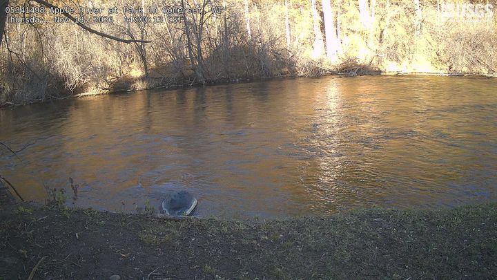
Camera at the gauge
Camera at the gauge, newest image Agency data#
Source
Source: U.S. Geological Survey HIVIS camera (NIMS API), newest image at build time; the image file is served by USGS. Fetched Nov 19, 2:08 PM CST. Credit: Camera images: U.S. Geological Survey, HIVIS.
How today compares with past years
Key facts Historical record#
Source
Sources: USGS Water Data API and USGS annual peak streamflow.
- Apple River above Park In Somerset is USGS gauge 05341498 in St. Croix County, Wisconsin; it drains 545 square miles.
- USGS daily flow records here run from Oct 17, 2023 to Nov 16, 2026.
- Highest annual peak flow on USGS file: 1,120 cfs on Jun 21, 2024 (3 annual peaks, 2024 to 2026).
Flood record and history1 section: The biggest floods here, day by day
The biggest floods here, day by day Historical record#
Source
Source: USGS annual peak streamflow (instantaneous peaks; peaks USGS codes as historic, a daily mean, a dam failure, a lower or upper bound, or with an unknown date are left out) and USGS daily mean flows (Water Data API), from 3 days before to 10 days after each peak; floods before the daily record began are skipped. A daily mean averages the whole day, so it runs below the instantaneous peak. Two peaks within 14 days count as one flood. Days are counted inside that 14-day window.
The largest flood in this gauge's daily record peaked at 1,120 cfs on Jun 21, 2024. For each of the biggest floods: how high the daily flow ran and how long it stayed above half the peak.
| Flood | Peak (USGS) | Highest daily mean | Days above half the peak | Back under half the peak |
|---|---|---|---|---|
| Jun 21, 2024 | 1,120 cfs | 1,060 cfs on Jun 21 | 14 | not by Jul 1 |
| May 1, 2026 | 888 cfs | 866 cfs on May 1 | 10 | May 8 |
| Jun 29, 2025 | 684 cfs | 663 cfs on Jun 29 | 14 | not by Jul 9 |
Daily values, measurements and rating3 sections: Daily mean flow · USGS field measurements · Gage height to flow rating
Daily mean flow Live gauge#
Source
Source: USGS Water Data API (daily values where USGS has published them; otherwise the mean of continuous readings on that gauge-local date, shown only with at least 80% of expected readings).
| Date (gauge-local) | Mean flow | Note |
|---|---|---|
| Nov 19, 2026 | – | Partial day (229 of about 288 readings) |
| Nov 18, 2026 | 254 cfs | Mean of readings, not yet published by USGS |
| Nov 17, 2026 | 280 cfs | |
| Nov 16, 2026 | 288 cfs | |
| Nov 15, 2026 | 290 cfs | |
| Nov 14, 2026 | 311 cfs | |
| Nov 13, 2026 | 325 cfs | |
| Nov 12, 2026 | 331 cfs | |
| Nov 11, 2026 | 343 cfs |
USGS field measurements Historical record#
Source
Source: USGS Water Data API field measurements, the 10 most recent site-visit measurements with a flow value, fetched Nov 18, 6:05 PM CST. The measurement quality shown is the USGS measurement rating as published.
| Date | Measured flow | Gage height | USGS measurement quality |
|---|---|---|---|
| Oct 22, 2026 | 257 cfs | 3.08 ft | Good |
| Sep 9, 2026 | 300 cfs | 3.27 ft | Good |
| Aug 7, 2026 | 211 cfs | 2.94 ft | Good |
| Jul 9, 2026 | 370 cfs | 3.12 ft | Good |
| Jun 8, 2026 | 263 cfs | 2.69 ft | Good |
| Apr 7, 2026 | 685 cfs | 3.32 ft | Fair |
| Mar 25, 2026 | 526 cfs | 3.06 ft | Good |
| Feb 27, 2026 | 426 cfs | 2.94 ft | Good |
| Nov 20, 2025 | 278 cfs | 3.12 ft | Good |
| Nov 20, 2025 | 278 cfs | 3.12 ft | Unknown |
Gage height to flow rating Historical record#
Source
Source: USGS rating table for the gauge, thinned for display, fetched Nov 19, 3:04 AM CST. Ratings are provisional and change with the channel.
Line: current USGS rating, gage height (ft, horizontal) to flow (cfs, vertical). ● latest reading, 2.99 ft and 216 cfs.
Watershed, water quality and land4 sections: E. coli samples on this stretch · Drought Monitor, Saint Croix County · State water quality assessments near the gauge · Upstream watershed characteristics
E. coli samples on this stretch Agency data#
Source
Source: Water Quality Portal (EPA, USGS and state agencies), E. coli results at stations on this river within 9 miles upstream and downstream, found by USGS NLDI river navigation, fetched Nov 18, 6:05 PM CST. Credit: Water samples: Water Quality Portal (EPA, USGS, states).
| Sample date | E. coli | Station |
|---|---|---|
| Jul 13, 2026 | 46 #/100mL | Apple River - Close To A Private Bridge That Crosses The Apple River From Cty Rd C To Rivers Edge Restaurant And Campground. The Restaurant\0092S Address Is 1820 Raleigh Rd. (WIDNR_WQX-10017343) |
| Jul 13, 2026 | 28 #/100mL | Apple River - North Of The Bussiness Hwy 64 And 35 Bridge Inside Of Somerset (WIDNR_WQX-10017341) |
| Jul 13, 2026 | 32 #/100mL | Apple River - Apple River Hide-A Way Campground (WIDNR_WQX-10017342) |
Drought Monitor, Saint Croix County U.S. Drought Monitor#
Source
Source: U.S. Drought Monitor weekly county statistics (National Drought Mitigation Center, USDA, NOAA), map date Nov 10, 2026, fetched Nov 19, 3:04 AM CST. Credit: The U.S. Drought Monitor is jointly produced by the National Drought Mitigation Center at the University of Nebraska-Lincoln, the United States Department of Agriculture, the National Oceanic and Atmospheric Administration and the National Aeronautics and Space Administration. Map / Data courtesy of NDMC.
Source figures are cumulative: each row counts the county area in that category or any worse one, so the rows are not shares that add to 100%.
| Category | Share of county area, week of Nov 10, 2026 | Previous week |
|---|---|---|
| No drought | 0.0% | 0.0% |
| Abnormally dry or worse (D0 to D4) | 100.0% | 100.0% |
| Moderate drought or worse (D1 to D4) | 100.0% | 100.0% |
| Severe drought or worse (D2 to D4) | 0.0% | 26.3% |
| Extreme drought or worse (D3 to D4) | 0.0% | 0.0% |
| Exceptional drought (D4) | 0.0% | 0.0% |
State water quality assessments near the gauge Agency data#
Source
Source: EPA ATTAINS assessment units within about a quarter mile of the gauge, as reported by the state, fetched Nov 19, 3:04 AM CST. Values are the state's assessment, quoted. Credit: Water quality assessments and watershed data: U.S. Environmental Protection Agency.
‘Not supporting’ means the state rates this water below its goals for some use; it is not a swim advisory. This is the state's Clean Water Act designated-use assessment (a multi-year regulatory status), not a current bacteria or recreation advisory.
| Water (EPA report) | State rating | Cleanup plan | Assessed |
|---|---|---|---|
| Apple Falls Flowage | Fully Supporting | N | 2026 |
Upstream watershed characteristics Agency data#
Source
Source: U.S. EPA StreamCat, watershed-wide metrics; land cover from the 2019 National Land Cover Database. Static values, fetched Nov 19, 3:04 AM CST.
Sources and method18 data sources, how the percentile is calculated, disclaimer
- USGS Water Data API, NLDI, daily statistics. Terms
- National Weather Service api.weather.gov. Terms
- EPA AirNow current air quality (airnowapi.org). Terms
- NOAA River Forecast Center precipitation estimates and NWS radar imagery. Terms
- OpenStreetMap via Overpass. Terms
- Recreation.gov RIDB (federal recreation facilities). Terms
- USGS PAD-US public land. Terms
- GBIF.org occurrence search API (fish records, CC0 and CC BY only), with US common names from ITIS (itis.gov web services). Terms
- U.S. Naval Observatory Astronomical Applications Department, Sun and Moon data for one day (aa.usno.navy.mil/api/rstt/oneday). Terms
- NOAA National Water Model guidance (via NWPS). Terms
- NOAA Regional Climate Centers ACIS. Terms
- NOAA Climate Prediction Center 8 to 14 day outlook (NWS map service). Terms
- USGS HIVIS gaging-station cameras (NIMS API). Terms
- Water Quality Portal (EPA, USGS, state agencies). Terms
- U.S. Drought Monitor. Terms
- EPA ATTAINS. Terms
- NOAA National Water Prediction Service (flood stages, river forecast, National Water Model). Terms
- USGS The National Map (USGS Topo map service). Terms
USGS daily statistics, downloaded Nov 20, 2026
Percentile method: trailing 24-hour mean compared with USGS daily percentiles for Nov 19.
Percentile is estimated from USGS published daily percentiles. Readings are provisional until USGS reviews them. Not endorsed by USGS, NOAA or the National Weather Service. Not for navigation or safety-of-life decisions; the absence of an alert is not a statement that conditions are safe.